Sizes
Stock
QTY
PRICE
Total
Delivery
 
PAPER
 
 
4
FROM £ 8.99
 
 
ENCAPSULATED / LAMINATED
 
 
2
FROM £ 14.99
 
 
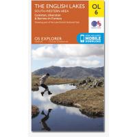
OL 6 Lakes South Western
Hover mouse over large image for a zoom view, click smaller images to access zoom view
OL 6 Lakes South Western
Ordance Survey OL6 Lakes South Western 1:25,000 map
Area covering Coniston, Ulverston & Barrow in Furness. The 'Active' maps are 'encapsulated' weather proof maps. We also offer the OS classic paper map
  • Explore the highest point in England, Scafell Pike, or follow the River Esk with the Ravenglass and Eskdale Railway
  • Double-sided map specially designed for walkers, off-road cyclists, horse riders and all involved in outdoor activities
  • The South-Western area map is one of four OS Explorer maps covering the English Lakes
  • The OS Explorer Active range of OL maps now includes a digital version of the paper map, accessed through the OS smartphone app, OS Maps
Customer Reviews

No reviews yet, if you have bought this item, log in to review your purchase.

Shopping Cart
You have an empty shopping cart
Shopping Basket
EMPTY
General Links
  Shows & Exhibitions
  Links
  Delivery Information
  Terms & Conditions
  Login
  Register
 
Secure & Convenient Payment
Worldpay Payments Processing
We Accept
VisaElectronDelta
MastercardMaestro
JCB
 
Secure Site
Icicle Mountaineering Products automatically reverts to our secure site for checkout and contact pages. If you want your entire session to be SSL encrypted, click below.
Click padlock to go Secure